Finally, a trip report.
A few years ago, I went on my first backpacking trip in New Hampshire's White Mountains with my good friend Dick. We hiked the Franconia Ridge, from Mt. Liberty to Mt. Lafayette, and anyone who has hiked this particular section can attest to it's grandeur. The weather was phenomenal and the alpine, ridgeline hiking quickly had me hooked on this awesome range.
The White Mountains are a range at the northern end of the Appalachian Mountains, and contain by and far the highest concentration of the most rugged peaks in New England, forty-eight of which tower above sea level by at least 4,000 feet, the highest being Mt. Washington at 6,288. As in most areas with such abundances of peaks over a certain elevation, there is a "club" of sorts composed of those individuals willing to climb all said peaks. New Hampshire's forty-eight 4,000 footers is no different. It was shortly after that first trip to the Franconia area that we decided we were going to make it a goal to join the club. This is a slow and ongoing project, but this trip got us up to the 20 peak mark. With such limited time for trips, we try to make the very most of them when we do get out. On this particular trip, originally intended to be a nice warm-up, we had a 12-mile day one, bagging three peaks and a day two climbing only two new peaks, but a long and arduous 18 miles.
After a solid week of rain, and a long graduation party laden weekend, Dick and I set off around 5:00 a.m. in his trusty Volvo, the kingpin of many of these trips. Some 4 hours, a few gallons of gas and coffee later and we were pulling into the Lincoln Woods visitors center, one of many areas funded by the National Forest Service in the area providing information, some accommodations, and most importantly for us, parking. After choking down some leftover barbecued chicken and Schaefer, and making some final pack adjustments, we headed down the Lincoln Woods Trail under the morning's gray overcast.
After a few miles of long and flat but scenic former railroad, we entered what is affectionately known as the Pemi wilderness (likely because no one really knows how to pronounce Pemigewasset), and started on the massive and rugged gains and drops in elevation that make us love the Whites so much.
As we've long since found out, peak-bagging is a less than glorious game. Mile long spur trails in the rain for non-existent views is no better than it sounds. We were greeted atop the Bonds (Bondcliff, Mt. Bond, and West Bond) by 100% humidity and average winds. Standing there, where it is said to be some of the best views in the Whites, we could see a few yards in front of us. On the summit of Mt. Bond we took shelter behind a rock slab and cooked some soup for lunch.

Soon after we decided to press on to out destination for the night, the Guyot tentsite. We've stayed at this particular site before and It's got a nice little shelter that we planned to stay in. While it hasn't exactly been technically raining, everything is pretty wet and evening rain is predicted. We figure, it'll be nice to stay dry in the shelter and not have to fuss with a tent. As expected, we weren't the only ones with this idea so we had some company in the shelter. Upon arriving, we were greeted by a group of six or so local high schoolers and two teachers/chaperones/guides who were spending a few days in the backcountry in lieu of taking finals, a pretty sweet deal if you ask me. I was expecting a long night of listening to truth or dare and headlamp light card games, but the youngsters were asleep before Dick and I had finished with dinner. They must have walked far that day, they had a tremendous amount of gear as well. Overall it was a nice night, and the lack of the "in-season" fee's was great.

Due in part to our early bedtime, we were able to get a bright and early start on what would turn out to be a hell of a day. We ascended Mt. Guyot to the AT, where we traversed over two tremendously slow miles of rotten snow to the peak of South Twin, for our 4th total summit of that particular peak. There we diverged from the AT to the south which came as a relief because with snow like that, meeting our mileage goals would have been difficult. We saw a few Spruce Grouse along the way, which I had to include a picture of. They're confident enough in their camoflauge to earn the name "Fool Hens." Needless to say we got close enough to grab them, nevermind close enough had we intentions to shoot one. Some game bird.

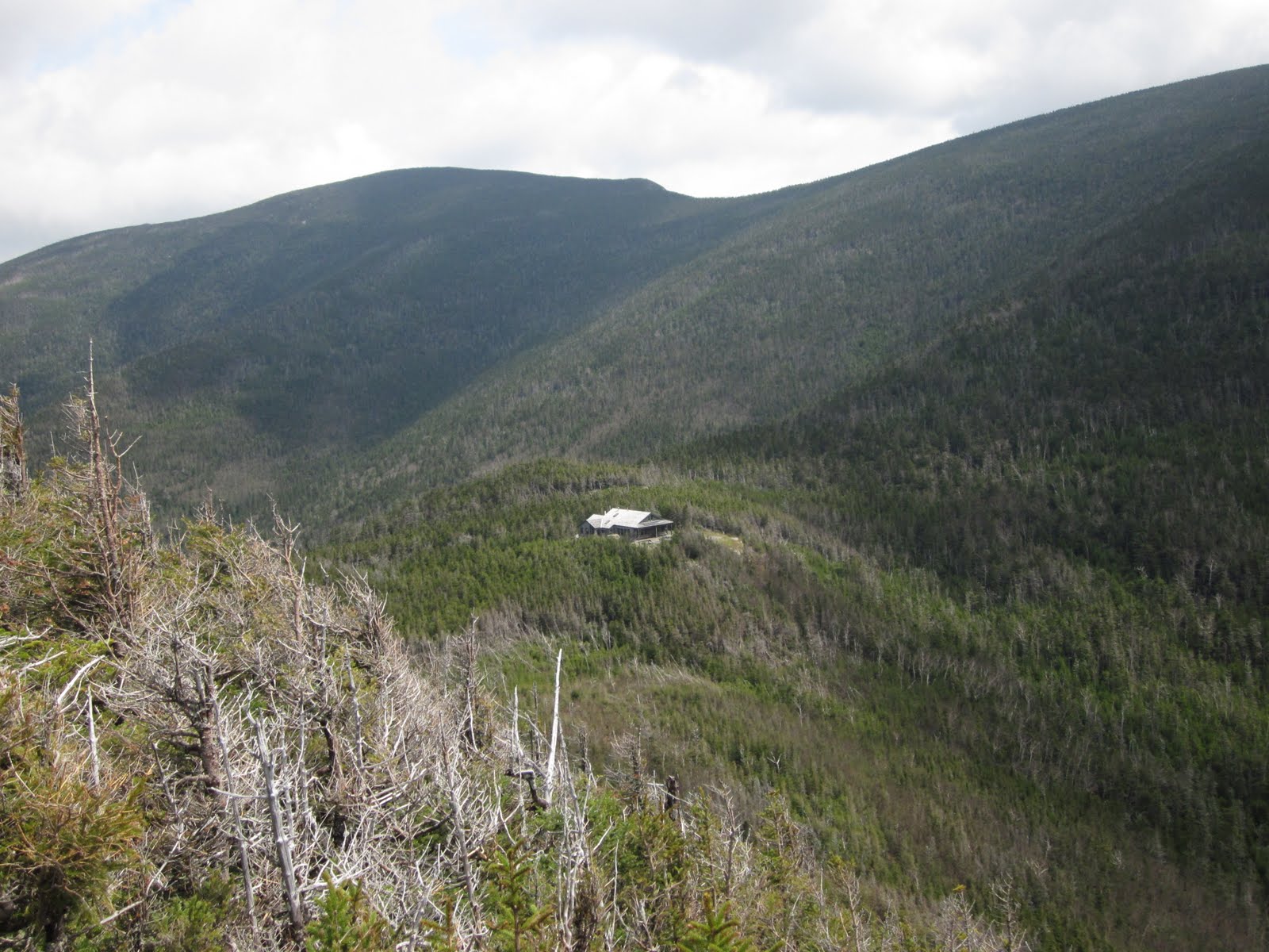
We soon found our way to the Galehead Hut, where we got some water and chatted with the caretaker for a while. If you're looking for a more plush backpacking experience check out the hut system. It's a good idea, and a great place to stop for clean drinking water, but otherwise not my cup of tea. From there a short spur trail led us to a previously skipped peak with absolutely no views. Luckily along the trail there was a overlook that afforded us a good look at the hut.

At this point the trip really hasn't even started yet, or at least it would come to feel that way. From here we descended down back into the Pemi with high speed and sprits about the weather's turn for the better. What lie ahead of us though was the infamous Owl's Head, or whats technically known as the Un-named peak above Owl's Head. Owl's Head being a cliff on the mountain's south face. In any event it made the list and it's a tree covered peak all alone in between the Franconia and Twin ranges, with no really direct routes, barely making the cut at 4,025 ft. We were approaching it from the north, where there were no trails leading to the summit. Having been warned by the caretaker at Galehead not to attempt to bushwack to the summit from the north we were left with pretty much one option, and that was to follow the Lincoln Brook trail circumnavigating the peak around the north and western sides. As it turns out, this is a path seldom traveled.

After plenty of blow downs like that and a few good river crossings, the trail dwindled down to a mere footpath and continued to get ever smaller and perplexing to follow. At the very moment I had decided we were no longer on the trail, I would see a faint boot print in the mud or a yellow trail blaze. Whoever marked the trail must have had strict instruction to not waste any yellow paint and thus strategically place the small rectangular blazes in the absolute minimum of spots.
It got interesting to say the least and I had an absolute blast. I can see why no one would want to travel this trail other than if you wanted to climb Owl’s Head and happened to be approaching from the north, but I would totally do it again. It was a much more wilderness experience than I’ve had in the Whites; I was fully expecting to run into either a bear or a moose. Or both.
After some five miles of tromping through snow, mud, streams, swamps and the like, we made it to an unmarked trail intersection which we could only presume was the approach to the summit of Owl’s Head. On the map it was clear that we’d be doing some climbing, so before we headed up we decided to sit and have some lunch. It was a good thing we did, because climb we did. One mile straight up a rockslide.
When we finally reached what seemed like the top, we were directed down a narrow path through the gnarled and fallen conifers by an arrow made of rocks. Apparently there was some controversy as to the true summit of the mountain, but the path led us there where we were greeted by this glorious spectacle. Best views we had the whole trip.

Slowly but surely we made our way back down and quickly embarked on our journey to the next stop, a tentsite near Franconia Falls, some ten miles away. Luckily for time’s sake, the trail on this side of the mountain was much more worn in; it would be the obvious choice for day-hikers seeking to bag Owl’s Head. At around the fifth river crossing the trail inconveniently diverted a good half mile in the wrong direction before intersecting with the trail to the trail that housed the tentsite we were so looking forward to at this point. I could see on the map that the river pretty much avoided this costly detour and I figured that there would be a footpath staying on the west side the river leading pretty much right to our destination, so when I saw what resembled a footpath at the appropriate river crossing, naturally I turned onto it. Within a matter of yards I had lost it. I soon picked it up again and followed it precariously deeper into the woods and away from the river.
Now this trail, unlike before was really unmarked and really difficult to follow. At this point I’m following indentations in the mud and the path I would intuitively choose had I been officially bushwhacking. After exclaiming about seeing a number of moose tracks I realized that we were, in fact, following a moose trail − confirmed by fresh droppings. No sooner did we realize that we were deep in moose country and the only logical option was to navigate back to the river by sound though the hopelessly thick undergrowth.
This is the part of the trip where things get a little bit intense and I don’t take out my camera for a while because I’m trudging through marshy streams because that’s virtually the only way I can make it through the brush. Reluctant to have not actually seen a moose, we made it to the river where I realized we had likely not saved much time at all, which really didn’t surprise me at all. Sometimes I think I put myself in those situations intentionally… I love bushwhacking, what can I say?
When we finally got to the river, I found the footpath I had originally expected to be there, right along the rivers bank. I made sure not to lose it again, focusing literally every ounce of my dwindling attention span to stay on it. I was following divots in the mud and sections of moss worn off logs and rocks. I slipped into what is sometimes referred to as “the zone” and hurried along, seemingly floating above the trail.
We had little to no time to observe the actual Franconia Falls, but it appeared to be a very nice spot. Would have been a nice spot for a drink of water and all that, but it was getting dark. Once we finally reached where on the map showed a red trail splitting off and crossing over to the other side of the East Branch Pemi River to the tentsite, I realized there was no signs indicating it’s presence. Much to Dick’s dismay I led us through another river onto an island where we followed a short trail to the other side where we found the most behemoth river crossing yet. About fifty yards across and what looked to be a good three feet deep in places. I had looked at the map enough times and I knew we had to cross so I jumped right in and waded across rather than second guess myself and take out the map for the 12th time. Sure as shit, the tentsite revealed itself and Dick and I rejoiced with some dry socks and supper. PBR and Ramen never tasted so good.

The next morning it soon became obvious that the weather for our last day out was perfect. Unfortunately for us the rest of the trip only included an easy four mile walk out, rather than the majestic peaks we’d climbed in the rain on Monday. Both of us pretty worn out, we decided to skip the dayhike of the Flume we had originally planned and headed to the Woodstock Inn to drink Pig’s Ear Brown Ale while we waited for lunch to start being served.
A hearty cheeseburger and a tall beer usually concludes all my forays into the woods, and this time was no different. I hope this hasn’t been torturously long, those of you who may have made it this far. I didn’t want to leave out any details;)